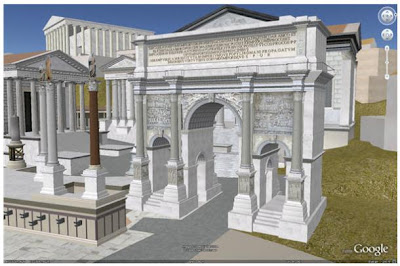
Ancient Rome 3D on Google Earth: Delicious!

After a post about maps, this is an interesting follow-up note: Google Earth launched yesterday “Ancient Rome 3D”. This is a joint project of Google and the University of Virginia’s Institute for Advanced Technology in the Humanities (IATH). It’s also the first time Google Earth includes an ancient city.

For all of us enthusiasts of Ancient Roman history, this is an amazing and delicious tool. The model shows the city (“Rome Reborn”) as it existed in 320 AD, recreating detailed models of more than 6,700 buildings and monuments. Some, like the Coliseum, also feature extremely detailed interiors. The images are completed with historical information in a new layer.

As this was developed, aiming the creation of an attractive educative tool, Google announced a curriculum competition in conjunction with the release of this new layer. Six K-12 educators who create the most interesting curricula based around the Ancient Rome 3D layer will receive new Mac laptops, classroom projectors, and a digital camera. Good luck 😉

Mapping Crime: Are you feeling safe in your neighbourhood?

The Mayor of London and the Metropolitan Police Authority (MET) developed a site where you can check the city crime map (following NYC and other cities experiments). It shows interactively where crime is occurring at a local neighbourhood level, providing all crime stats in the area. This crime mapping includes burglary, robbery and vehicle crime. It also allows the user to find local police, to check the safest neighbourhoods, to report a crime online or to send the Met’s a question or message, among others. It uses Google maps and the platform is still in progress.

However, it can be a useful local e-government initiative. Citizens can verify their residential areas crime, but also, be “closer” to the London police. Globally speaking, the project goals are clearly informing citizens, but also diminishing local crime and augmenting the feeling of security and trust in law enforcing agents. Of course it can’t show with perfect accuracy the real local situation, considering that crimes must be reported to be presented. In addition, as the website emphasizes sometimes victims can’t describe with precision the exact place where the crime occurred. Nonetheless, having the possibility to file crimes through the Internet might contribute to raise crime reports…that consequently might make the picture worse….and therefore augment fear. But, maybe I’m extrapolating too much…This is just a tool (that can even be used by criminals :-): it won’t reduce crime on its own. It must be part of a wide strategy…and I hope it is.


Some examples with Westminster postcode:

I also found Wikicrimes that allows checking crimes in different countries. This collaborative platform was conceived by Vasco Furtado, Professor at University of Fortaleza, Brazil. The technological infrastructure is provided by IVIA.
Quick historical note:
Crime mapping history definitely includes sociologi
sts from the so called Chicago School. In the beginning of the 19th century, urban sociologists from the University of Chicago started to use maps as a visual tool to illustrate the spatial distribution of social problems in the city. In this group we can find Park and Burgess, who developed the concentric circles model (The City, 1925), supporting the theory of human/social ecology. The concentric circles consist in a diagram that shows different zones in the city, zones that expand from the CBD (central business district). The theory illustrates five concentric zones. These zones are defined by their residential composition, moving from the very poor and socially deviant, in the inner zone of transition to a peripheral suburban commuter ring. So, areas of social and physical deterioration concentrate near the city centre and more wealthy areas located near the city's boundary. This theory aims to explain the existence of social problems such as unemployment and crime in specific Chicago areas. Shaw and McKay (Juvenile Delinquency and Urban Areas, 1969), also part of the Chicago Sociology group, constructed several maps to show the location of the residences of more than 10,000 male delinquents. Shaw and McKay observed that the spatial distribution of juvenile delinquents’ houses stayed constant over the years. They seek to demonstrate that crime was a normal response to social characteristics of a community, sustaining the Social Disorganization theory. However, as I’m extending myself too much on the earlier contributes of sociologists to crime mapping ;-), crime maps go back to 1829. Borden Dent in “Brief History of Crime Mapping” shows that its origins can be found in France. In 1829, Adriano Balbi and André Michel Guerry (a geographer and a lawyer with passion for statistics) created three choropleth maps showing the relationship between violent and property crimes and educational levels (later called “moral statistics”). Of course, that with computers and new technologies (locative media, for instance, have been essential), new techniques and tools for mapping crime were developed and improved.

Is Success Killing the Internet?

A Web of Wide Open Innovation….Or Closed Appliances?

Is the Internet as we knew it – an open platform for innovation – a victim of its own commercial success?


These are the mottoes for a conference at the New American Foundation, tomorrow, 5th of November in Washington (USA). This event will bring together Jonathan Zittrain and Adam Thierer. Zittrain is the author of the “Future of the Internet and how to stop it”. He argues that the openness of the Internet brought connectivity and creativity, but at the same time spam, viruses, cyber-terrorism, etc. For Zittrain the future of the Internet might be closed networks and restricted devices, subverting the spirit of the Web. On the other hand, Adam Thierer, author of “Manifesto for Media Freedom” emphasizes that fears about a loss of openness and innovation are exacerbated. They are a façade used for more “net neutrality” and regulations. For Thierer the Net is undoubtedly alive and digital innovation and online openness are a reality as they were never before.

Yes, this will be an extremely interesting conference and debate of ideas about the future of Internet policy and regulation. But, don’t worry; even if you’re not in Washington, you can “attend” this event, as it will be webcast live here, starting at 3:30 EST.

Keynote Speakers:

Jonathan Zittrain

Professor of Law, Harvard Law School

Author,
The Future of the Internet

Adam Thierer

Senior Fellow and Director, Center for Digital Media Freedom,

Progress & Freedom Foundation

Co-Author, A Manifesto for Media Freedom

Michael Calabrese

Director, Wireless Future Program,

New America Foundation

Moderator

David Gray

Director, Workforce & Family Program

New America Foundation

(My quick comment to the event on “comments” LOL)

Post for Portuguese Speakers

For all of you who speak Portuguese (and we are not so little, as Portuguese is the 6th most spoken language in the world), Julieta Leite, a friend architect working at Université René Descartes, is doing an online survey to collect data for her PhD research about cities. The survey does not ask for any personally identifiable information and will only take you 5 minutes to answer. So please, take some time to participate and to publicize it.
Thank you,